


Trying to track rapid climate change with traditional field surveys is a bit like trying to put out a forest fire with a bottle of water — it’s just too slow and too limited. The only way we can truly keep up with the scale of environmental destruction is by shifting our eyes to the sky.
This is exactly where Morocco mobilises resources in cases of natural disasters such as earthquakes and fires.The North African state launched on November 20 a new observation satellite, with the aim of assisting with a range of tasks, including the prevention and management of natural disasters, observing the process of desertification, and coastal surveillance. Mohammed VI-B was put into orbit via Arianespace’s Vega launcher, which lifted off from Guiana Space Centre in French Guiana.
This is the perfect example of how high-res satellite images become the most valuable ally. We can monitor vast, inaccessible areas from Northern Africa to the Amazon or Antarctica without the carbon footprint of an expedition and quickly respond to disasters.
What Actually Counts as High-Resolution?
To get real value out of this technology, you have to understand “resolution.” It sounds technical, but it’s actually simple: resolution is the size of the ground that one single pixel covers. If a satellite has 30 cm resolution, one pixel represents a 30 cm square of the Earth. As sensors improve, satellite high-resolution images are becoming shockingly sharp, bridging the gap between space observation and aerial photography.
Here is how I break down the categories based on what you can actually see:
- Ultra High (≤15cm): At this level, you aren’t just seeing a construction site; you can spot the specific tools left on the ground. It is the closest we can get to drone-level detail from orbit, perfect for inspecting critical infrastructure.
- Very High (16-49cm): At 30 cm, you can distinguish individual trees, count wildlife in open areas, or spot illegal logging trucks. It offers the precision needed for enforcement.
- High (50-99cm): You can clearly see property boundaries, road networks, and large vegetation patches. It’s great for mapping but lacks the texture to identify smaller objects.
- Medium & Low (1m+): While you won’t see cars, these resolutions are vital for the “big picture”, like tracking massive algae blooms or regional deforestation trends that span hundreds of miles.
We saw the heartbreaking necessity of this precision following the earthquake in Morocco’s High Atlas Mountains. In remote villages like Tafeghaghte, accessible only by narrow, dusty tracks, satellite imagery revealed that nearly every building had been flattened. The images offered a grim reality check on the construction materials; because the homes were made of mud bricks, they crumbled into fine rubble rather than leaving life-saving air pockets, a detail that lower-resolution scans might miss.
Monitoring Deforestation and Land Degradation in Morocco
Deforestation is a crime of opportunity. It thrives in remote areas far from the eyes of authorities. According to the World Resources Institute, the tropics lost 3.7 million hectares of primary forest in 2023-equivalent to losing 10 football fields of critical habitat per minute.
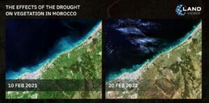
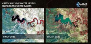
But the deforestation issue is sharp not only in the Amazon. Located in the biodiversity-rich Mediterranean basin, Morocco faces increasing climate vulnerability and severe droughts. It’s 9 million hectares of forest, mostly in the North and Atlas regions, that serve three critical roles:
- Economic Anchor: Forests contribute 1% to GDP and support 7 million people, half the rural population.
- Cultural & Agricultural Hub: They provide essential livestock feed (up to 32% for cattle) and protect the soil and water cycles needed for farming.
- Ecological Shield: They prevent erosion and house threatened species.
Despite their value, forests are degrading rapidly. Human pressures like overgrazing and firewood collection are exceeding the land’s capacity, while forest fires were responsible for 64.1% of tree cover loss since 2001. Using hi-res satellite images, conservationist specialists in Morocco can now spot the early warning signs, like a jagged dirt road cutting into a reserve, weeks before the major clear-cutting actually begins.
This technology empowers us to do three critical things:
- Monitor silent degradation: We can track moisture levels to detect drought stress and gradual thinning, identifying at-risk forests before they turn into dead zones.
- Verify restoration claims: It is easy for companies to claim they planted a million trees; satellite data proves if those trees actually survived.
- Track fragmentation: We can see exactly how ecosystems are being sliced up, which isolates wildlife populations and destroys biodiversity.
Transforming Megacities: Smarter Planning, Not Just Bigger Building
More and more cities today are poorly planned with endless traffic, disappearing parks, and infrastructure that crumbles under pressure. This is where real-time high-resolution satellite images become essential. Considering infrastructure, we can assess bridges’ health with the help of traffic load analysis due to satellite data.
As a result, city authorities can prioritize repairs before accidents happen. Flood risk is no longer a matter of guesswork. Planners can predict them and manage water resources, minimizing the risk of severe consequences. And we can finally track the green in our grey. Urban density is at our fingertips now, allowing us to plan parks and open spaces with mental well-being in mind.
Climate Change Monitoring: The Planetary Health Check
To me, the scariest part of climate change is that its biggest drivers are often invisible. We can’t see methane clouds or sea levels rising by millimeters with the naked eye. This is where high-resolution multispectral satellite imagery steps in — acting as a definitive planetary thermometer.
These sensors allow scientists to track critical vitals that determine our future. Satellites like NASA’s OCO-2 spot invisible CO2 and methane leaks, missions like Sentinel-6 measure rising oceans with centimeter precision. Moreover, we can finally track the rate of ice loss, documenting the alarming retreat of polar glaciers year over year.
Supporting Sustainable Development
There is a tired argument that saving the planet hurts the economy. I think that is nonsense; true sustainability is just another word for survival. By weaving live high-resolution satellite images into our blueprints, we stop flying blind.
We can spot a flood plain before we build a school on it, or optimize crop yields without draining the water table dry. This technology ensures that our “progress” doesn’t collapse under the weight of the changing climate five years down the road. It turns environmental protection from a burden into a strategic advantage.
Conclusion: The Clarity to Act
In the past, we could claim we didn’t know the extent of the damage until it was too late. High-resolution satellites have killed that alibi. They provide a daily, unblinking audit of our impact, from the vanishing Amazon rainforest to the smog choking our megacities. We now possess the god-like ability to see every scar on the Earth’s surface; the question is no longer about whether we have the technology to save the planet, but whether we have the will to actually use it.